The current trend to digitise maps doesn’t work for me. I only use the map on my phone when I’m lost or need to navigate the streets of a town or city that I’m not used to. I find the screen too small to give me perspective and not helpful when planning a route.
I find the 50 X 37 inch Ordnance Survey Explorer series of maps too cumbersome to pull out and refer to when I am out cycling and walking. They have a useful scale of 2½ inches to the mile and I find them more suitable for laying out on a table.
A road atlas is good for planning longer journeys and I’ll happily tear out pages from an old one, highlight my intended route in fluorescent yellow, fold the pages to size and slip them into the map holder on the top of my bike’s bar bag.
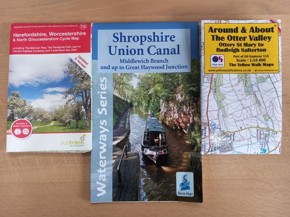
There are however alternatives. If you are looking for detail, then The Yellow Walk maps produced by Yellow Publications Ltd are excellent. These have a scale of 4 inches to the mile. I first used one of these when walking in the Malvern Hills. They are two sided and when fully opened are only 18 X 12½ inches and cost less than the price of a pint. They only cover selected areas and not the whole of the UK.
A series of maps particularly good for cycling are those produced by Sustrans, the charity responsible for the National Cycle Network. Their regional maps have a 0.57 inch to the mile scale. When fully opened they measure 31 X 25 inches. These are also two sided with one side consisting of selected circular routes and detailed street maps. Like the yellow maps, these are plasticised and therefore rainproof. They fold down to 6 X 4 inches that will fit neatly into the back pocket of a cycle shirt.
My third alternative maps are the Waterways Series, produced by Heron Maps. These follow Britain’s Canal network. They vary in scale but are around 1.1 or 1.2 inches to the mile and are useful to walkers and cyclists as well as canal boat users. These linear maps show around a mile or so either side of the canal. Unlike most maps, because they try to get as much length of canal onto the map as possible, they do not follow the convention of having north at the top and south at the bottom of the sheet. The two maps in my possession both have true north pointing to the top right hand corner of the page. Others I suspect may differ.
These maps show you where you can find car parks, pubs, cafes, tea rooms and WCs. Every bridge has a metal plate on it giving you its number and these maps list you the number and where applicable the bridge’s name.
For the canal user there is also the important detailed information that they would be looking for such as boatyards, moorings, refuse and sewage disposal points and places they can find diesel fuel, as well as obvious canal features like locks, aqueducts and tunnels.
I find walking and cycling alongside water particularly enjoyable. I have never found it a problem turning around and heading back the way that I have already walked. Covering the same ground in different directions always gives me a different perspective. Following canal towpaths mean that you are unlikely to get lost. If you intend to do a circular walk then it’s likely you will need to combine this with another map.
Although some retailers stock these maps, all of them may be obtained through the publisher’s respective internet sites:
Yellow Maps: https://www.yellowpublications.co.uk/
Sustrans Maps: https://shop.sustrans.org.uk/collections/regional-map
Heron Waterways Maps: http://www.heronmaps.com/index.htm
635 words 28/3/23 Peter Linfield ©