All posts by Pete

Plegmund

(The later part of the 9th Century – North Mercia)

‘There is a messenger looking for you Father!’

‘Saxon, Celt or Dane?’ the holy man asked cautiously, these were dangerous times and he knew that whatever the answer, it could have very different consequences.

‘Saxon, from Wessex,’ said the man.

‘English? ’ The Holy man grunted and smiled to himself, he knew he was safe. ‘What does Alfred want with me?’

Of course, there is no evidence that this conversation actually took place. But a thousand years ago we know that Alfred, King of Wessex came looking for a scholar who lived in the marsh land south of the River Mersey.

St Peter’s Church, Plemstall.

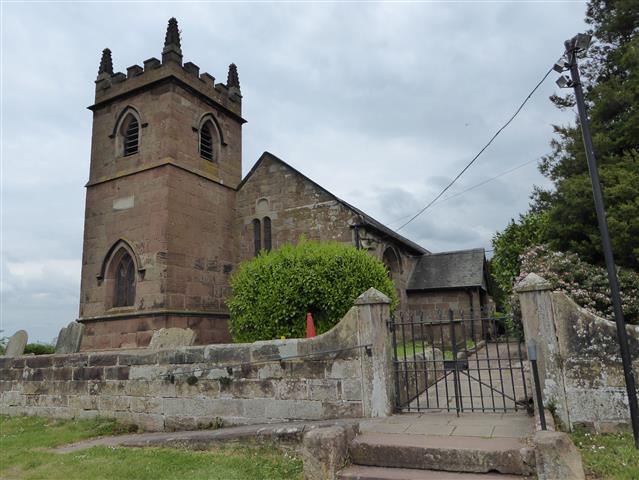
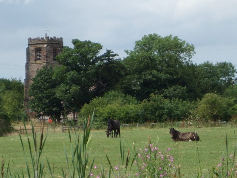
Four miles north-east of Chester stands the isolated church of Saint Peters, Plemstall, the holy place of Plegmund. The current church dates back to the 15th century before that, there was an earlier church dating back to the 12th century. But the history, the myths, and the legends that surround this place go back even further. One legend tells of a fisherman, caught in a storm, whose prayers for safety were answered  when he was washed ashore here at a place then known as the Isle of Chester. In return, he built a church and dedicated it to St Peter the fisherman. This may have been as early as the 5th century.

By the 9th century this place was the home of Plegmund, a Christian, a man of God, living in an ungodly world. Back then, Plemstall stood on the northern limits of Mercia. To the North  was Northumbria and in the hills to the West were the Celts.  The Danes held much of the land north of Watling Street. In 869 they had tied King Edmund to a tree and filled him with arrows.

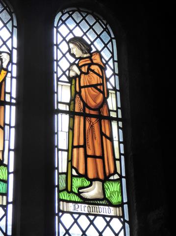
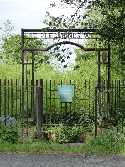
Today, Saint Peter’s Plemstall stands at the end of a narrow lane; its only company is a bungalow and a couple of nearby farms. 300 yards from the Church stands a well, protected by iron railings.  Today, it is known as St Plegmund’s well, but a thousand years ago it was a freshwater spring amongst the tidal marshes of what we know today as the River Mersey. Here, Plegmund baptised local children. But as well as being a Holy man, he was a scholar and one of the cleverer men of his age. One early description of him was as ‘an eremite’; even then people had a tendency to drop their Hs.

St Plegmund’s Well, Plemstall Lane, Mickle Trafford, Chester

At some point Plegmund was called away to serve both his King and the church. In 891 Alfred appointed him as the 19th Archbishop of Canterbury. During his time, Plegmund was to visit Rome on two occasions and after Alfred’s death in 899, he crowned Alfred’s son, Edward the Elder, King of England. Plegmund held the post of Archbishop until 914.

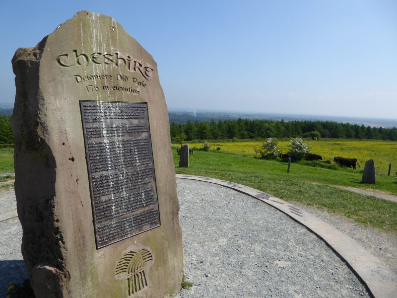
Today, Plemstall’s slightly elevated position isn’t obvious until you enter the graveyard to the east; here you can see that the land falls away towards the River Gowy. Beyond that, the landscape rises again toward Cheshire’s sandstone ridge; this comes to an abrupt end, a few miles away, with the sandstone escarpment of Helsby Hill.  In the 9th century, Helsby would have been a Viking settlement!

This is  a quiet, tranquil place and your imagination doesn’t have to work hard to visualise what it would have been like a thousand years ago when this land was either under threat or under the control of the Danes. In the years that followed, Chester fell to the Danes, only for them to be ousted by, Æthelflæd, Lady of the Mercians and Alfred’s daughter.

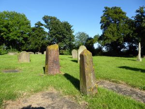
Today the church and the surrounding area are sensitively managed. Behind the church is a wild flower meadow. In the lane leading to the church new woodland has been planted. A visit in spring rewards the visitor with a variety of birdsong. Finches, tits and warblers predominate, and overhead you might hear the song of a high flying skylark. Across the fields can often be heard the repetitive call of a Yellowhammer. Beyond the church and alongside the river there is an owl box perched on a pole. I don’t know whether it is occupied, but I imagine that the wetlands alongside the river would provide an ideal territory for such a bird.

Whenever I visit Plemstall, I experience a feeling of contentment. There is something about the place that defies today’s world. The past is so evident here that you can almost touch it. Maybe Plegmund left something of himself here.

St Plegmund – South Cloister Window, Chester Cathedral.

A Cheshire View

To get  some perspective, one must first climb to a high place.

There are many routes to the top of Pale Heights. Earlier this year I approached it from Mouldsworth, passing Eddisbury Lodge and Nettleford Wood. At other times I have climbed it from Gresty’s Waste, Yeld Lane, The Delamere Forest Visitor’s Centre and Barns Bridge Gates. I think that the most testing route however is the one that takes the service road leading up from Delamere Station to the communication masts. This route makes little consideration for the hill’s contours and uses the most direct route to the top passing Old Pale Farm on its relentless climb.

Close to Kelsall, this seemingly unremarkable hill can be identified by the three telecommunication masts that stand on its summit. At 577 feet, the hill looks over the Cheshire plain and provides spectacular views to the north, east and west. It’s central position in the county means that the hill rewards both walker and cyclist with probably the finest panoramic views that they will find of Cheshire.

I’m not a big fan of uphill cycling, but Pale Heights is a favourite that I consider worth the effort. I cycle up here at least once each year; it’s a climb that tests my stamina and fitness. Eighteen months ago I bought a new bike and the first thing I did, to put it to the test, was cycle up this hill.

Pale Heights is modest hill, particularly when compared with Moel Famau at 1,820 feet, the highest point in the Clwydian hills, and the most notable feature on the western skyline. To the north-east you can see Manchester Airport and over in a south-easterly direction is Jodrell Bank. In midsummer the sun can be seen setting into Liverpool Bay. This is one of the few places from which you can see both Liverpool and Manchester.

To the east there are views towards the Peak District, including Shining Tor on the Derbyshire border, whose 1,834 foot summit is the highest point in the county and three times higher than Pale Heights. Beyond can be seen Kinder Scout, Derbyshire’s highest point.

Much nearer, beyond the farm and situated on the hill’s south-east shoulder, stands Eddisbury Hill fort, an Iron Age earthwork that gives the local parliamentary constituency its name. That area is also called Old Pale. The term Pale is used to describe an area of enclosure land; possibly in this case it was used to protect deer or livestock from poaching and theft.

Delamere forest, which surrounds Pale Heights today, represents the last remnants of the ancient hunting forest of Mara once belonging to Edward, The Black Prince. Amongst the prince’s titles was, Earl of Chester. Edward was son to Edward III and father to Richard II. He was a Prince however destined never to become a King.

Today, Pale Heights is marked by a modern-day stone circle, each stone originating and representing one of the seven counties that can be seen from this point. The central stone represents Cheshire and is made from the local Sandstone. This stone is encircled by a set of small metal plaques identifying the many landmarks that can be seen from this vantage point.

From Chester, Pale Heights is a great bike ride and can be cycled in a little over an hour each way. It’s a good place to go with other people but it’s also a great setting if you want to be alone. As in biblical times, high places can still be good locations to talk with God. Regardless of your faith however, Pale Heights is always a good place to fill your lungs with fresh air and get some perspective.

The Voorman Problem – ‘Solipsist only has one “L” Doctor’

I first came across The Voorman Problem when I read David Mitchell’s 2001 novel, Number9Dream.  It’s a short story, an Easter egg, hidden inside the larger story. In my copy of the book it can be found between pages 28 to 36.

Set in Tokyo, Number9Dream follows the story of Eiji Miyake, a young Japanese man searching for his father. In one scene, he has tracked him to a cinema where The Voorman Problem is being screened.

In 2012, film makers Mark Gill and Baldwin Li, decided to make the film a reality, scripted the idea and created a 12 minute film based on the David Mitchell’s story. Starring Martin Freeman and Tom Hollander the film went on to critical acclaim and was nominated for: the best live action short film at the 2014 Academy Awards.

The Story/film has sinister overtones and a tentative grasp on reality.  Supporters of Brexit could enjoy reading/watching this.

Update: 3rd August 2020

The Voorman Problem is often available on Youtube, however it is removed  occasionally because of copyright infringement. The person who uploads the video slightly changes the title’s spelling . I will not post a link because of  becoming complicit. This does not however prevent anyone from watching it.

The film is available to be purchased or downloaded legally for a fee.

If you do get the chance to watch it in full, it’s worth a view, if nothing more then to see how a short story can be converted into a superb, little film.

Hopefully, Voorman’s last line, in the film, will not turn out to become prophetic!

Copyright for the film belongs to: Honlodge Productions Ltd

A posey, a pig and a paperback book.

A Name in Stone

Front of Nelson cottage in Parkgate, Cheshire.

Deserted by the sea that once provided its livelihood, Parkgate stands on the Dee estuary. The village is a fascinating place to visit; many of its buildings are unique and some have stories to tell. Nelson Cottage in Station Road has a story, and the property is easily identified by its cobbled frontage.

Early in the 19th century this cottage was the holiday retreat of the portrait painter Albin Roberts Burt. Albin had a good reputation and specialised in miniature portraits. Half a dozen of his pictures hang in Britain’s National Portrait Gallery. In November 2016 a London auction sold Albin’s two inch sketch of Lord Nelson for an estimated £12,000.

Albin moved around quite a bit in his lifetime, but in 1822 he was living in Chester. In early December that year he decided to visit Liverpool, and took his nine year old son along with him.

Historic facts can be difficult to verify, but reports suggest that the journey was done by boat using the Shropshire Union Canal from Chester to Nether Pool: now part of Ellesmere Port. On route he would have passed St Lawrence’s church at Stoak which may have been undergoing restoration at that time. The church dates back to the 14th Century, but was restored in 1827. At Nether Pool, father and son transferred to a ferry to cross the Mersey basin to Liverpool.

Having finished their day’s  business they began the return journey home. That evening, however, tragedy struck. The Prince Regent steam ferry ran out of fuel and the boat was at the mercy of the strong winds. A hurricane struck the Liverpool Bay area, and nine people fell overboard from the ferry that night including Albin’s son, Nelson.

Saddened following the loss of his son, Albin walked along Parkgate beach and collected black stones. On returning to Station Road he used the stones to spell out his son’s name in front of the cottage. The stones remained loosely in place until the 1920’s when they were set in cement.

View of St Lawrence’s church Stoak from Shropshire Union Canal tow path.

I often cycle along the canal towpath between Chester and Ellesmere Port, and think about the young boy and his father making that last fateful journey. At Stoak, I can see St Lawrence’s church three hundred metres beyond the canal. I have family resting in the churchyard. I’m aware that a small boy lost in a storm almost two hundred years ago also lies there. I’ve known this for many years but until recently didn’t know his name.

Whilst researching my article on Parkgate for Best of British magazine I discovered this grave was the final resting place of young Nelson.

Grave of Nelson Burt, St Lawrence’s churchyard, Stoak, Near Ellesmere Port, Cheshire.

On a summer evening I visited St Lawrence’s churchyard. I could look up my relatives and see if I could also find Nelson’s grave. It wasn’t hard to find; it was the one closest to the south of the church tower. Nelson may have the oldest grave in that churchyard and its position means that he probably gets the maximum amount of sunlight. The headstone inscription explains the circumstances of his death. An interesting thing about this grave is that it has both a head and a footstone.

On the 5th December 1822 a small boy died under tragic circumstances. Maybe he could have become a  famous painter like his father, or a great leader of men like his namesake. We will never know, but today we still know Nelson Burt’s name because it has been set in stone.

Miniature portrait of Nelson Burt aged 8, painted by his father Albin Roberts Burt.

Painting reproduced with the kind permission of Claudia Hill @ Ellison Fine Art.     http://www.ellisonfineart.com/

Following the Signs

Welcome to my blog. My name is Peter Linfield, I write, I cycle, I’m a Christian and I live in the historic city of Chester.

Northern Saxon warrior alongside the Shropshire Union Canal near Chester.

Back in 2013, I encountered an Anglo Saxon warrior, only two miles from my home. He was guarding the most northerly point of the Mercian Way. He didn’t speak – but told me I was 101 miles from Bewdley in Worcestershire. At that time I’d never heard of Bewdley, let alone been there.

I discovered that the Mercian Way was part of Sustrans’ National Cycle Route (NCR) 45, the other end of which was 270 miles away in the cathedral city of Salisbury.

At the height of summer, I took advantage of the long days and packed my tent into my cycle panniers and made the train journey south. Sustrans signs would direct me home.

For five days I followed the signs as I meandered my way north through the English countryside. The route took me over Salisbury plain, past Stonehenge, through the Vale of Pewsey and the stone circle at Avebury. I crossed the River Thames north of a town called Cricklade and cycled along canal tow paths through Gloucester, Worcester and Chester.  I crossed the Cotswolds, the Wrekin and the Peckforton Hills.  I got lost in Swindon but found my way out with the aid of a compass. On day four, I reached Bewdley and spent a Sunday morning searching the Wyre Forest looking for the Saxon warrior that marked the southern end of the Mercian Way.  After that I joined the Severn Valley Way, sharing my route with its river and famous railway. This took me through Bridgnorth to Ironbridge. Leaving the River Severn, I carried on to Whitchurch in Shropshire and back to my home in Cheshire.

At the end of my journey I wrote an account of the trip and called it ‘Following the Signs’. I have adopted this name also for my blog. Here, I will tell you about my cycling trips, my writing journey and other things I’d like to share.

NCN Route 45 Sign at Salisbury Cathedral